Water Supply Planning
Wise and thoughtful water supply planning is critical to ensure a secure future for the state. Meeting future water needs must be done in a manner that considers all solutions and addresses the varied water needs of Colorado and its citizens. The CWCB is focused on helping prepare for and meet Colorado’s future water supply needs.
In the past two decades, Colorado’s water community has united to form one of the most robust stakeholder-informed water planning processes in the country. Together, the Interbasin Compact Committee (IBCC) and nine basin roundtables developed a vision for the state’s water supply future:
We envision a Colorado that balances municipal, industrial, agricultural, environmental and recreational water needs and promotes cooperation among all water uses.
The vision is supported by numerous regional water supply goals, detailed in each Basin Implementation Plan. When evaluated together, all goals support the development of more balanced statewide water supply strategies in the Colorado Water Plan.
Many local water providers and regional groups have projects or plans in place to address increasing water supply gaps. These projects include considerations of growth into existing supplies; conservation; reuse of existing or future consumable supplies; agricultural transfers; or new water supply projects. The CWCB tracks local and regional water projects to help identify whether we, as a state, are on track to fill the state’s water supply gaps. This effort is a large focus of the basin roundtables' current updates to their 2022 Basin Implementation Plans.
- Colorado’s Water Supply
-
Within Colorado, most areas receive less than 20 inches of natural precipitation each year, so most of the state requires irrigation to grow crops or to support urban landscapes. In the high mountain areas, which generally receive more than 20 inches of precipitation, almost all yearly precipitation falls as snow.
Colorado also uses both renewable surface water and non-renewable groundwater to meet our water supply needs. While the state’s river systems generate an average 16 million acre-feet of water each year, about two-thirds of this water is obligated to leave the state under various interstate compacts and agreements. About 80% of the water is on the Western Slope, yet about 90% of the state’s population resides on the Eastern Slope. Most of Colorado's irrigated agriculture lands are on the Eastern Slope as well.
- Colorado’s Water Demands
-
Colorado’s current and future water use can be separated into three broad categories:
Agriculture // The major consumptive user of water in all of the state’s basins, agriculture represents about 86 percent of our state’s water use. While agriculture still will be the largest water user in the future, the state’s future water needs likely will have an impact on irrigated agriculture, farms and ranches.
Municipal and Industrial // Colorado’s population is expected to nearly double to between 8.6 and 10 million people by 2050, with the majority residing in the Arkansas, South Platte and Metro basins. This population growth will drive a significant need for additional water to meet future municipal and industrial demands. Colorado also needs water for "self-supplied industrial" uses such as energy development, thermoelectric, snowmaking, breweries and other large water-reliant industries.
Environment and Recreation // Also known as nonconsumptive uses, environmental health, recreation, and tourism are all vital to Colorado. Millions of people within the state participate in outdoor recreational activities that are connected to Colorado’s water resources. Water-related activities, such as fishing, paddling, commercial rafting, wildlife viewing, camping, skiing and other snow sports, together infuse between $7 and $8 billion into the state’s economy and employ about 85,000 people across Colorado. These "nonconsumptive" water needs call for creative solutions to share water resources between all industries.
- What is a Supply-Demand Gap?
-
In the Technical Update to the Water Plan (2019), a full suite of modeling tools available from CDSS made it possible to estimate new future supply and demand gaps under all five planning scenario conditions. Gaps were evaluated for both agricultural and municipal and industrial (M&I) uses. Gaps were calculated as the difference between the amount of water available to meet agricultural or M&I diversion demands and the full diversion demand. In other words, gaps reflect the amount by which agricultural or municipal demands could be shorted because of inadequate supplies.
Explore key supply and demand findings from the 2019 Technical Update below
The infographics give specific information about each sector's findings. Read a text-only version of the infographics.
- Agriculture
-
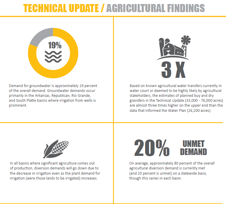
Agriculture currently experiences a gap, and it is projected to increase statewide. Increases may be modest under the Business as Usual and Weak Economy scenarios but may be more substantial under scenarios that assume a hotter and drier future climate (the Cooperative Growth, Adaptive Innovation, and Hot Growth scenarios) due to decreasing supply and increasing crop irrigation requirements. Because Colorado's agriculture economy currently experiences a gap, an "Incremental Agriculture Gap" was quantified to explore how a future 2050 gap could increase beyond what agriculture has historically experienced under water shortage conditions.
Irrigated acreage is projected to decrease in most basins due to
urbanization, planned agricultural to municipal water transfers, and groundwater sustainability issues.Gaps under the Adaptive Innovation scenario are significantly less than Hot Growth despite similar assumptions related to future climate conditions, which demonstrates the potential benefits of higher system efficiencies and emerging technologies that could reduce consumptive use; however, in return flow driven systems, conservation in one area could impact water supplies downstream, so thoughtful approaches are necessary.
- Municipal and Industrial
-
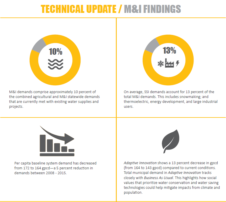
Municipal & Industrial users do not currently experience a gap, but a growing population and potential impacts from climate change are projected to create gaps. Projected M&I gaps tie strongly to assumptions regarding future 2050 population and climate conditions. Conservation efforts, however, can create significant future benefits in lowering the gap, as demonstrated by comparing the Adaptive Innovation
and Hot Growth scenarios (which have similar assumptions on
population and climate). - Environment and Recreation
-
Environment & Recreation gaps were not directly quantified in the Technical Update to the Water Plan, but tools were developed to help evaluate potential risks that impact aquatic habitat, species and boating due to flow conditions. These potential future risks are documented in various sections of the Technical Update but are not a part of the gap estimate numbers.
Climate change and its impact on streamflow will be a primary driver of risk to environmental and recreation assets.
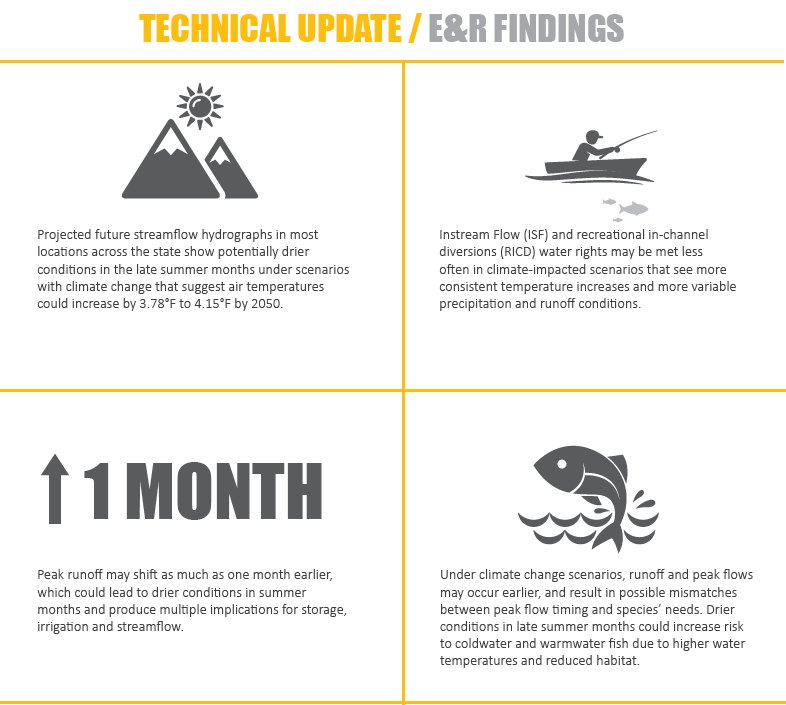
Projected future stream flow hydrographs in most locations across the state show earlier peaks and potentially drier conditions in the late summer months under scenarios with climate change. Drier conditions in late summer months could increase risk to coldwater and warmwater fish due to higher water temperatures and reduced habitat. The degree of increased risk is related to the level of stream flow decline. Instream flow rights and recreational in-channel diversion water rights may be met less often in climate-stressed scenarios.
Focus area maps created as part of the Basin Implementation Plans also show where environmental and recreation attributes are focused. Use this Focus Area Mapping tool link to learn more.


